Russia Earthquake: Why the Small Tsunami?
Megaquake Strikes Russia: Why the Tsunami Wasn't as Catastrophic as Feared
**Imagine this:** An 8.8 magnitude earthquake, one of the strongest ever recorded, rips through the remote Kamchatka Peninsula. Panic ensues. Millions evacuate. But the devastating tsunami everyone anticipated? It largely failed to materialize. What happened? Let's dive into the science behind this seismic mystery and discover why early warning systems are crucial.
 A Giant Undersea Clash: Understanding Megathrust Earthquakes
The Kamchatka Peninsula, nestled in the infamous **Pacific Ring of Fire**, is a hotbed of seismic activity. This volatile region sits atop a collision zone of tectonic plates—massive pieces of Earth's crust constantly shifting. The Pacific plate, a colossal oceanic plate, grinds against the smaller Okhotsk microplate. Picture two massive puzzle pieces slowly, relentlessly pushing against each other.
A Giant Undersea Clash: Understanding Megathrust Earthquakes
The Kamchatka Peninsula, nestled in the infamous **Pacific Ring of Fire**, is a hotbed of seismic activity. This volatile region sits atop a collision zone of tectonic plates—massive pieces of Earth's crust constantly shifting. The Pacific plate, a colossal oceanic plate, grinds against the smaller Okhotsk microplate. Picture two massive puzzle pieces slowly, relentlessly pushing against each other.
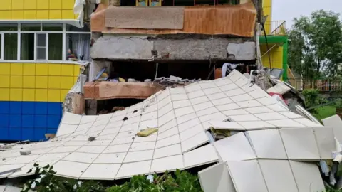 These plates aren't smoothly gliding past; friction builds over millennia. Then, *BOOM*! The pressure releases in a cataclysmic event: a megathrust earthquake. This isn't your average tremor; it's a rupture stretching potentially hundreds of kilometers. The 1952 Kamchatka quake, a 9.0 magnitude monster, serves as a chilling reminder of the region's potential—and this latest event occurred just 30km away! This is why understanding these geological forces is crucial for your safety.
Why the Tsunami Didn't Devastate Coastlines
These plates aren't smoothly gliding past; friction builds over millennia. Then, *BOOM*! The pressure releases in a cataclysmic event: a megathrust earthquake. This isn't your average tremor; it's a rupture stretching potentially hundreds of kilometers. The 1952 Kamchatka quake, a 9.0 magnitude monster, serves as a chilling reminder of the region's potential—and this latest event occurred just 30km away! This is why understanding these geological forces is crucial for your safety.
Why the Tsunami Didn't Devastate Coastlines
 So, a mega-quake hits—why the relatively tame tsunami? The answer lies in a complex interplay of factors. While the initial underwater displacement of water generates a tsunami, several variables dictate its height and impact.
The earthquake's depth plays a crucial role. A shallower quake generally results in larger tsunami waves. The initial reports suggested a relatively shallow depth, but experts suggest the actual depth may have been significantly greater—potentially minimizing the tsunami's size.
So, a mega-quake hits—why the relatively tame tsunami? The answer lies in a complex interplay of factors. While the initial underwater displacement of water generates a tsunami, several variables dictate its height and impact.
The earthquake's depth plays a crucial role. A shallower quake generally results in larger tsunami waves. The initial reports suggested a relatively shallow depth, but experts suggest the actual depth may have been significantly greater—potentially minimizing the tsunami's size.
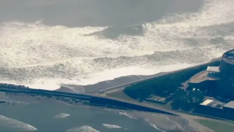 Furthermore, the seafloor's topography and coastal geography act as natural buffers. Think of the coastline as a complex maze. The way tsunami waves navigate this maze dramatically affects their final height and force. The waves that did hit reached up to 4 meters in some areas—significantly less than the devastating waves of the 2004 Indian Ocean and 2011 Japan tsunamis. The difference? Topography, coastal structures, and the sheer power of the initial wave.
The Power of Prediction: Early Warning Systems
Furthermore, the seafloor's topography and coastal geography act as natural buffers. Think of the coastline as a complex maze. The way tsunami waves navigate this maze dramatically affects their final height and force. The waves that did hit reached up to 4 meters in some areas—significantly less than the devastating waves of the 2004 Indian Ocean and 2011 Japan tsunamis. The difference? Topography, coastal structures, and the sheer power of the initial wave.
The Power of Prediction: Early Warning Systems
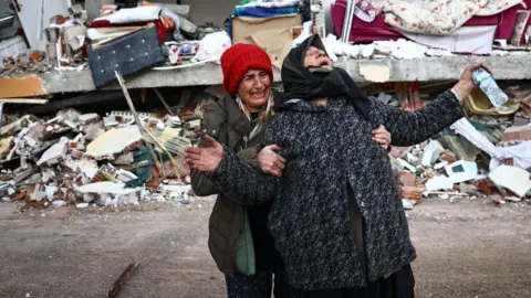 The absence of a catastrophic tsunami wasn't just luck. Advanced early warning systems played a pivotal role. Unlike the 2004 Boxing Day tsunami, which claimed over 230,000 lives due to the lack of a warning system, modern technology provided crucial time for evacuation. Millions heeded the warnings, significantly minimizing potential casualties. While scientists can't predict *when* an earthquake will strike, they *can* provide probability forecasts based on plate movement and historical data. The 7.4 magnitude quake ten days prior may have been a foreshock—a warning sign, though not a precise predictor. This highlights why ongoing monitoring by organizations like the Geophysical Survey of the Russian Academy of Sciences (GS RAS) is crucial, especially in anticipation of possible aftershocks over the coming month.
**What can we learn from this event?** The interplay between geological forces and technological preparedness is paramount in mitigating the risks of natural disasters. Understanding these factors is essential for your safety and for building resilient communities.
The absence of a catastrophic tsunami wasn't just luck. Advanced early warning systems played a pivotal role. Unlike the 2004 Boxing Day tsunami, which claimed over 230,000 lives due to the lack of a warning system, modern technology provided crucial time for evacuation. Millions heeded the warnings, significantly minimizing potential casualties. While scientists can't predict *when* an earthquake will strike, they *can* provide probability forecasts based on plate movement and historical data. The 7.4 magnitude quake ten days prior may have been a foreshock—a warning sign, though not a precise predictor. This highlights why ongoing monitoring by organizations like the Geophysical Survey of the Russian Academy of Sciences (GS RAS) is crucial, especially in anticipation of possible aftershocks over the coming month.
**What can we learn from this event?** The interplay between geological forces and technological preparedness is paramount in mitigating the risks of natural disasters. Understanding these factors is essential for your safety and for building resilient communities.
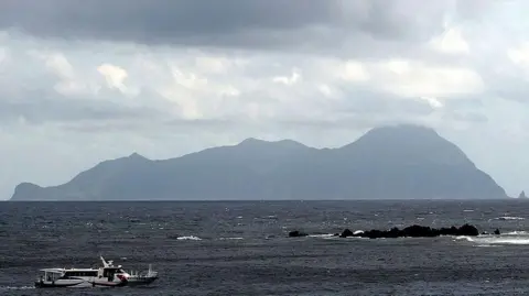
Image 1
Image 2
Image 3
Image 4
Image 5
Image 6


Comments
Post a Comment